

Case studies and projects featuring drones
The Territory’s unique and diverse environment offers an ideal testing ground for drone research and development (R&D) opportunities.
You can see some of these opportunities below. They highlight the innovative work happening and the potential for drone technology to support the NT economy.
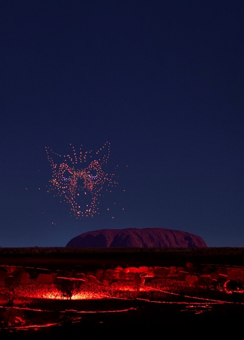
Wintjiri Wiru
Wintjiri Wiru, which means ‘beautiful view out to the horizon’ in the local Pitjantjatjara language, is the largest permanent drone show in the world. With over 1,000 drones, lasers and light projections, the show tells the ancient Mala story of the Anangu people.
The show is a culturally significant storytelling experience, developed in close consultation with the Wintjiri Wiru Working Group comprised of senior Anangu from Kaltukatjara and Mutitjulu. With Uluru as its backdrop, the show is narrated in Pitjantjatjara and Yankunytjatjara languages and accompanied by a traditional soundtrack created by members of the Anangu community.
Visitors are transported to a sustainably built amphitheatre to experience the immersive experience, told in light, above the ground. The drones, weighing 310g each can fly 3 metres per second and reach up to 100m in height during the show. The drones are launched from and returned to specially designed boxes which cool and charge the drones and protect them from the harsh conditions of Central Australia.
It is a ground-breaking show, which demonstrates the potential of drone technology for cultural tourism experiences. The show has provided significant economic benefits and job opportunities for the Yulara community and the Territory more broadly.
"When you choreograph over 1,000 drones to tell a story that's been told in the sand for more than 60,000 years and will now be told using cutting-edge technology for the world to see, it is important to honour the culture in every step of the process," CEO of Voyages Indigenous Tourism Australia Matt Cameron- Smith said.
"We are honoured we can share the cultural importance of the Mala story with our guests, through such an illuminating and captivating experience in the spiritual heart of Australia. As custodians of the land and part of the Mala story, the Anangu consultation group has carefully guided us on the Wintjiri Wiru experience, from conception to launch, to generously share their story with the world," he said.
As custodians of the land, Anangu hold the Mala story from Kaltukatjara to Uluru. To share their story, RAMUS designed and produced an artistic platform using drones, light and sound to create an immersive storytelling experience.
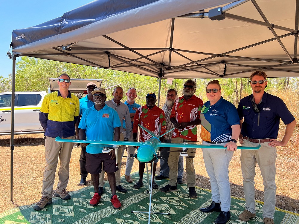
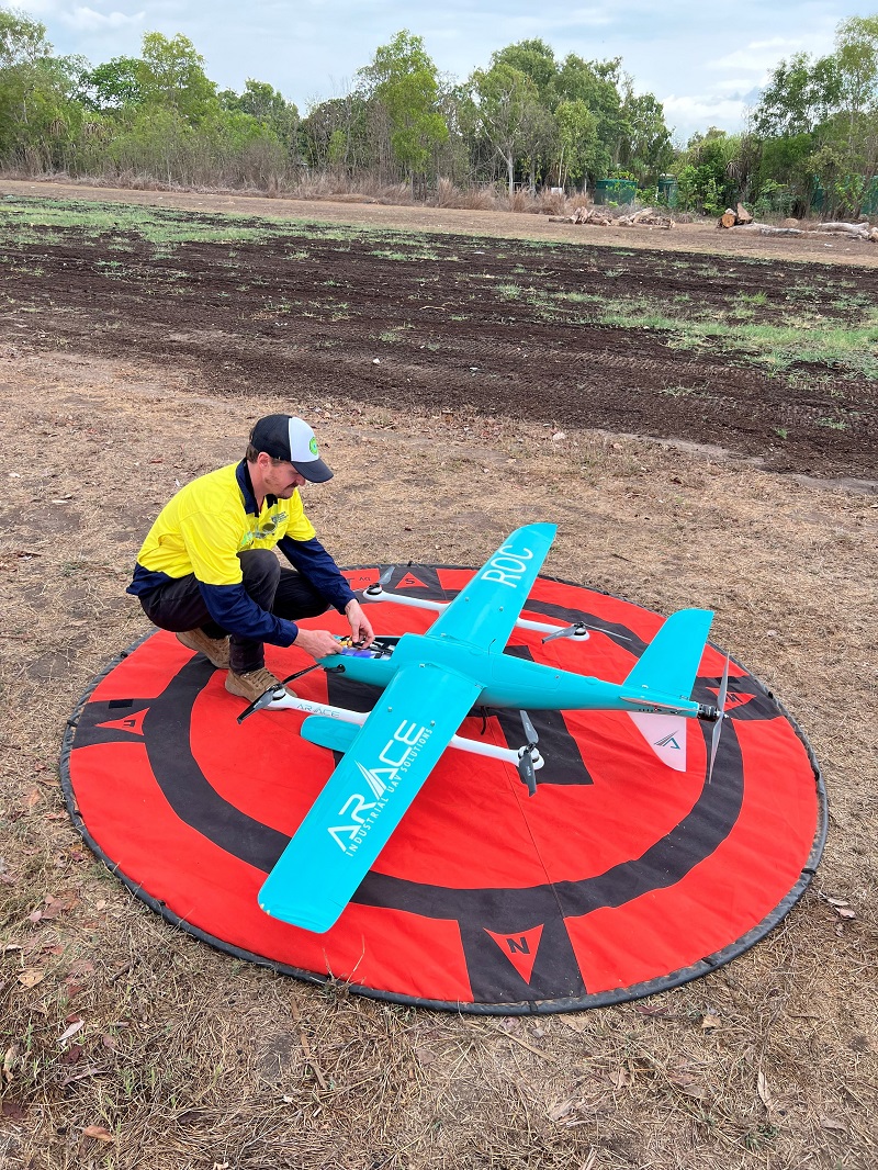
Bibi planes for health
The Bibi Planes for Health project, currently running in West Arnhem, is a partnership between the:
- iMOVE Cooperative Research Centre (CRC)
- NT Department of Health
- Charles Darwin University and
- Red Lily Aboriginal Corporation.
It aims to explore and solve the logistical, technological, and regulatory challenges of incorporating drones into the supply chain of health care for remote communities in the NT.
The delivery of time-critical medical items is a serious limitation and cost for healthcare in remote and regional Australia. Bibi planes have the potential to reduce the time and cost associated with medical delivery and save lives in remote and regional communities.
"Flying to remote NT communities is tough due to harsh operating conditions. Using our flight testing area, we're finding solutions to safely and reliably use drones for medical deliveries by overcoming technical challenges," North Australia Centre for Autonomous Systems (NACAS) Chief Remote Pilot Rebecca Ludgate said.
“Ensuring consistent ground-to-drone communications in regions with isolated infrastructure significantly contributes to these challenges. Once overcome, implementing medical delivery drones has the potential to transform the lives of isolated communities, by providing timely healthcare and connecting remote areas through improved logistics. Economically, a 25kg delivery drone is far safer than a road transport and when the range challenges are overcome far more efficient than a 757kg Cessna aircraft," NACAS Research Operations Officer Matthew Worrad said.
North Australia Centre for Autonomous Systems
The North Australia Centre for Autonomous Systems (NACAS) dedicates cutting-edge research and comprehensive training for unmanned aerial systems across various industries, businesses and sectors relevant to North Australia and the Asia Pacific regions. Strategically situated in Darwin, NACAS boasts a state-of-the-art engineering facility and flight-testing areas that provide unrivalled airspace for drone testing.
“NACAS acts as the northern hub for academia, government and industry, and enables drone manufacturers to showcase their products and integrate them with the evolving needs of end-users. Darwin's strategic location and unparalleled access to uncluttered airspace make it an ideal location to trial, test, and systems integrate emerging aviation technologies. Recognising autonomous technologies as a prominent area for investment and growth in the country, NACAS diligently works towards reinforcing connectivity between the academic and engineering advancements in southern regions and the NT," Director of NACAS Professor Hamish Campbell said.
Rise Project Consulting
Rise Project Consulting is an award-winning Territory business providing large-scale asset inspection and visualisation services using:
- unmanned aerial vehicle (UAV) drones
- 3D scanning
- unmanned surface vehicle (USV) bathymetric drones
- underwater remotely operated vehicles (ROVs).
Rise are remote northern Australian specialists with a deep understanding of the unique challenges of working in the remotest parts of the Territory having successfully delivered projects in over 80 remote communities.
“At Rise, we believe the value of drone technology can only be measured in the context of where it will be used. This is why we invest heavily in researching and testing our equipment to ensure that it can withstand the extremes of the Territory’s climate, and that it is robust enough to be transported to the most isolated communities. We also actively seek staff who are acclimatised to the extremes of the north and experienced working in remote Northern Australia,” Business Director Anna Goat said.
It is this commitment to research and development, and expertise that enable Rise to successfully undertake 319 UAV drone inspections of the GEMCO accommodation, Groote Eylandt, for South 32 and HK Solutions. This project required extensive logistical planning to ensure the equipment did not overheat. As well, it required careful battery and charging management and heat mitigation strategies for the pilots.
The inspections included roof images, external surface images and condition assessments. Rise were able to constantly fly UAV drones up to 10 hours a day, for 10 consecutive days in the tropical heat with no equipment or pilot failure.
Healthy Country Artificial Intelligence and Digital Training Program
The Healthy Country AI and Digital Training Program is a collaboration led by Traditional Owners and Indigenous rangers across Australia with the:
- Commonwealth Scientific and Industrial Research Organisation (CSIRO)
- North Australian Indigenous Land and Sea Management Alliance (NAILSMA) and
- Charles Darwin University (CDU).
It is designed to support those that are interested in becoming ‘Indigenous digital rangers’, where they learn to use technology to responsibly collect, analyse and use data and AI that complements Indigenous knowledge. This technology is also used to monitor how well on-ground actions are contributing towards healthy country goals.
The program has 3 objectives:
- engage Indigenous participants who are involved in caring for country activities across key parts of Australia
- enhance Indigenous rangers’ capabilities to use data and digital technologies to collect, access and use data for the evidence-based management of country, and support the protection of important areas and sites
- support networking opportunities for Indigenous land managers who are caring for country across Australia to enable peer-to-peer sharing and build connections for future opportunities.
“NAILSMA has been supporting Indigenous land and sea managers across northern Australia to use technology to help manage country for over 20 years. The challenge with new technology is to make sure people aren’t left behind and that opportunities are created on country and work within the local decision making process and cultural governance," CEO of NAILSMA Ricky Archer said.
"Drones have become a common tool in recent times and many of our on-ground partners have embraced the technology. NAILSMA partnered with CSIRO, Microsoft, CDU and the Telstra Foundation and worked with Indigenous land and sea managers in Queensland and the NT to develop and test training programs that matched the needs and use cases common across northern Australia.
We established a program that starts with really simple skills that everyone can learn and ramps up to more technical skills such as planning drone missions suitable for consistent site survey methods. We believe that having accessible micro-credentials that are relevant for the day-to-day operations of drones on country is one of the keys to expanding the impact of this technology in northern Australia” he said.
Manyallaluk school drone projects
Manyallaluk School, located 100km north-east of Katherine, has been using drones for innovative STEM education projects since 2018. The school initially purchased a drone to complete aerial surveys to monitor the movement of feral buffalo throughout the local area. Students used the scientific method to develop hypotheses, then flew the drone on weekly missions to photograph the herd along a stretch of winding creek. The data was then compiled and analysed to understand the movement patterns of the buffalo.
The project demonstrated the potential for drone technology to complement traditional knowledge systems used to care for country. Students presented the results at the NT Natural Resource Management Conference and were awarded a trophy for the project. The school plans to continue using the drone as part of the school curriculum and is considering how drones can be used to support wildlife monitoring and land management activities.
“When we began teaching at Manyallaluk School, we became increasingly aware of a Federal Government push to develop STEM learning as this is going to be increasingly vital, and already is vital. We really had no idea about STEM or what to do. Added to this, there was also a really wonderful increasing awareness of the importance and power of student voice. So when a couple of our year 6 boys said we should buy a drone for school, we jumped on the idea with both nervousness and excitement!
When we got the drone, our whole community was interested in it and it really did help with school engagement. We have so many stories of at-risk kids who began to like school because we have focused so heavily on using STEM for Learning on Country and then bringing that back into the classroom to make things like writing really exciting and relevant. It also builds relationships and assists in 2-way learning (teachers teaching kids and kids/community teaching teachers). In addition to the drone, we have also benefited from the purchase and use of spy cameras for wildlife surveys.
Our drone also helps build relationships through simple photography at community events and by assisting with beautiful footage in video tributes to loved ones who have passed-away at funerals. In the modern world of video games, even pre-school students can begin to learn the basics of operating a drone. Using hands-on, high-tech equipment is so empowering and engaging and has helped us to build-up our at-risk students and get them fully onboard with learning and leading," Principal of Manyallaluk School Ben Kleinig said.

Give feedback about this page.
Share this page:
URL copied!