

NT growers using satellite images for mango yield forecasting
Northern Territory (NT) growers contribute over half of the mangoes produced in Australia. The mango production in the Territory is expected to continue to increase in the foreseeable future. Increased production will require robust value chains for consistent supply of better-quality mangoes to national and international consumers. Accurate yield forecasting, prior to harvesting, is an essential component of this process, with satellite images of mango orchards at flowering / fruit set period, being used for fruit yield forecasting. An early season estimation of fruit yield will enable mango growers to organise harvest and packhouse labour, equipment and packing material, logistics, and trade deals.
Over the last three mango harvests, a number of different commercial and free or low-cost satellites imagery were evaluated to determine their usefulness for mapping and forecasting mango yield as well as being cost effective for growers to use. These included high resolution images from the World View (WV2 and WV3) satellites purchased from Geo-Image Australia; Images from PlanetLab; Landsat images acquired free from the United States Geological Survey website; and Sentinel 2 images also acquired for free from the website of The European Space Agency.
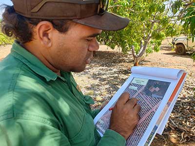
From these satellite images, yield variability maps (Fig 1 and 2) were developed using a ‘calibration’ method developed by the University of New England Applied Agricultural Remote Sensing Centre (UNE AARSC) over a number of years. A small number of trees per orchards had their fruit physically counted (Fig 3), allowing for the satellite image of all the trees to be calibrated for yield. This method ensures that influences on production such as management, pest, disease, irregular bearing years and weather variations are accounted for. The selection of only a small number of trees also offers significant labour and time savings compared to the current forecasting method where 2% of an orchard are physically counted.
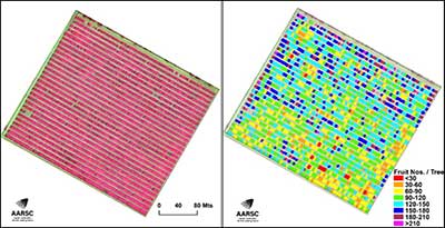
Yield variability maps have the ability to better inform the growers on where within and across season variability occurs in tree health and yield and as such inform the growers on where to undertake targeted management (irrigation, nutrition, others) to overcome the potential constraints.
The tree health and yield variability mapping were carried out within commercial mango orchards in the NT. For 2019-20 mango harvest season, 36 individual orchard blocks across seven farms were selected, which were increased to 220 blocks (from seven farms) for 2020-21 harvest season to further include different mango varieties (Calypso, R2E2, Kensington Pride, Honey Gold, Keitt), tree ages and management. On average, an overall accuracy of > 90% was achieved in fruit count estimation using satellite data (at the individual block level), a high improvement on traditional manual yield estimation method.
The accuracy achieved suggests that the reported process may provide as an effective tool for pre-harvest yield forecasting in the NT mango industry as well as a potential method for mapping yield variability, in the absence of a commercial yield monitor.
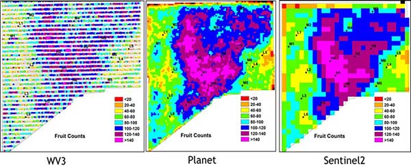
However, corresponding with accuracy is affordability of the technology for growers. Very high-resolution data, for example WV3, does incur a cost and therefore the use of multiple captures throughout a growing season or across large areas may end up being cost prohibitive. As such the AARSC and collaborating team also investigated the accuracies of lower resolution, low cost or freely available satellite platforms to determine the robustness of the methodology.
As seen in Fig 2, the prediction values obtained from all satellites tested were highly comparable. This outcome does provide mango growers with some choice on what platform and associated price bracket they are happy to adopt. In addition, the availability of historic imagery from these satellite platforms (particularly, from Landsat) does allow for the development of an alternate forecasting ‘time-series’ approach that can help better understand past relationships between canopy response to yield, disease, pest and seasonal variations for instance. Additional validation of these results was undertaken over Northern Territory growing regions, varieties and for 2021-22 season. The results created much interest and support from many of Australia’s mango growers and as such the team look forward to the ongoing development and then provision of this technology to growers in the very near future.
Acknowledgements
This research led by the University of New England and in collaboration with Central Queensland University, Northern Territory Department of Industry, Tourism and Trade and Australian Mangoes was funded by Hort Innovation with support from the Australian Government Department of Agriculture and Water Resources, as part of its Rural R&D for Profit program.