

A high-resolution cropland extent product for the Northern Territory
Identifying the land capable of being used to grow crops is important for regional and national level planning, import and export decision-making and policy decisions. The high-resolution cropland extent product is, for example, useful for preliminary understanding of agricultural croplands in terms of their spatial distribution patterns which can be employed to assess water availability and use.
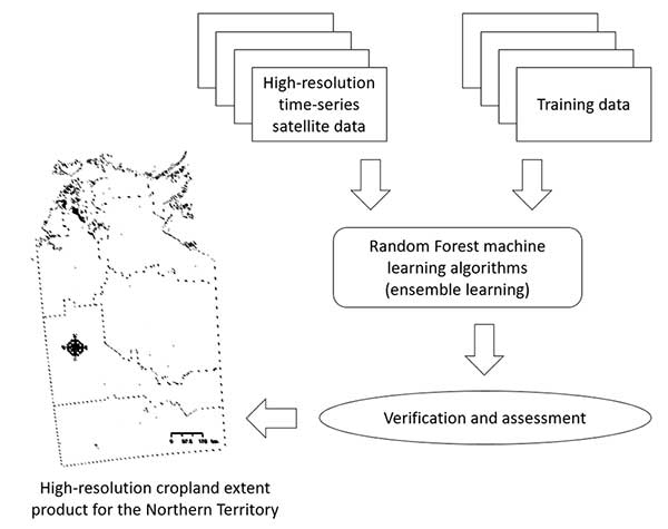
Remotely sensed vegetation indices were used with artificial intelligence to identify the land capable of being used to grow crops in the Northern Territory (NT) (figure 1), taking into account local climate, topography, and vegetation cover. High-resolution time-series satellite sensor data were used, with ground data extracted from published literature. An overall accuracy of 85% was achieved on a ≤32 square metre resolution.
This work was carried out as part of the Cropping team’s work on a Cooperative Research Centre for Developing Northern Australia funded project on broadacre cropping. Northern Australia agriculture is regulated by environmental and economic conditions. Historically, no broadacre cropping in the NT has proven successful. Interest in developing a profitable farming system for the NT remains. Combining historical data with contemporary crop simulations, the project will set starting points for the development of NT broadacre cropping systems. The data gathered through the Cropping team’s recent work supports these efforts.
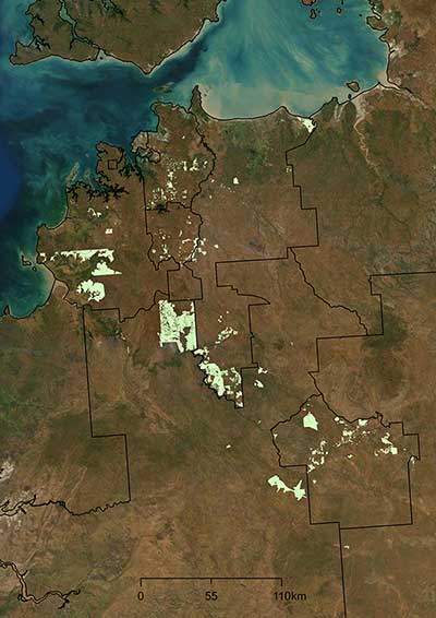
The land capable of being used to grow crops was found to be 0.24 million ha in the NT, with the regional ranking as follows (figure 2):
- 82,000 ha in Victoria-Daly region
- 53,000 ha in Cox-Daly region
- 53,000 ha in Marrakai-Douglas Daly region, and
- 35,000 ha in Katherine region.
Acknowledgement
The author acknowledges the financial support of the Cooperative Research Centre for Developing Northern Australia (CRCNA) which is part of the Australian Government's Cooperative Research Centre Program. The CRCNA also acknowledges the financial and in-kind support of the project participants.