Bushfire management enhanced with EO4NT grant
A toolkit to provide rapid high-resolution images of burnt land is being developed with the help of a Territory Government and Geoscience Australia grant.
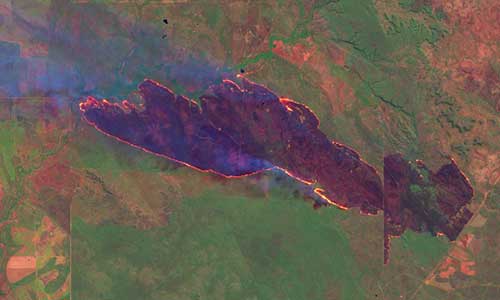
Charles Darwin University and its North Australia Fire and Rangelands Information service received a $97,000 Earth Observation for the NT (EO4NT) grant to create the tool. The tool will use earth observation data and sophisticated algorithms to dramatically speed up the acquisition of satellite images, process the images to highlight burnt areas and then create maps.
Charles Darwin University researcher Dr Rohan Fisher says the goal is to create a commercially viable product that allows agencies and businesses to produce high-resolution burnt area maps that can then be displayed on the North Australia Fire and Rangeland website.
“This mapping will greatly improve planning and operational risk assessment for bushfires that impact on those agencies and businesses,” he says.
“There is an increasing number of predominantly remote Indigenous-led NT businesses that receive significant income from reducing greenhouse gas emissions from bushfires through using sophisticated fire-management strategies.
“This fire management requires reliable, accurate high-resolution maps of burnt areas to guide their mitigation burns and bushfire response.
“This grant will assist the development of software tools to provide these data in a more accurate and regular way than ever before.
“Significantly, this project will also build on local skills and knowledge of country, supporting decentralised burnt area map-making with Indigenous ranger groups and building capacity in these predominantly Indigenous businesses.”
The project was awarded the grant under Earth Observation for the NT, known as EO4NT, a funding partnership between the Territory Government and Geoscience Australia and being led by Dr Patrice Weber.
The EO4NT grant program is designed to support companies develop earth observation-powered solutions that will enhance business productivity and performance, or overcome business challenges.
Earth observation data is often used to measure natural and urban environments, assess their current status and track changes over time.